
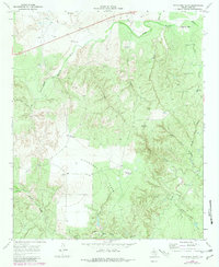
1968 Map of Pitchfork Flats
USGS Topo · Published 1971About this map
Deep ranching roots and water management define this landscape in King County during the late 1960s. The terrain is dominated by Pitchfork Flats and the sharp relief of Dog Town Mtn, where a series of deep canyons like Lynn Canyon and Wall Canyon cut through the high plains toward the South Wichita River. The map reveals a sophisticated network of upland water sources essential for cattle operations, evidenced by numerous named wells such as Krit Windmill, Owens Windmill, and Lynn Canyon Windmill.
Find a feature on this map
36 named features on this map. Tap any name to fly to it.
Don’t see what you’re looking for? This feature index may not catch every label — zoom into the map to look around manually.
Map Details
Editions of this 1968 Pitchfork Flats Map
2 editions found
Other maps of this area

1954 · Lubbock
USGS Topo · 1:250,000

1958 · Pursley House
USGS Topo · 1:24,000

1958 · Southerland Canyon
USGS Topo · 1:24,000

1959 · Bob Creek
USGS Topo · 1:24,000

1967 · Guthrie NW
USGS Topo · 1:24,000

1967 · Fourmile Hill
USGS Topo · 1:24,000

1968 · Pitchfork Ranch
USGS Topo · 1:24,000

1968 · Guthrie
USGS Topo · 1:24,000

1968 · East Afton NE
USGS Topo · 1:24,000

1985 · Dickens
USGS Topo · 1:100,000