
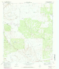
1967 Map of Guthrie NW
USGS Topo · Published 1970About this map
The 6666 Ranch North Camp anchors this 1960s landscape in King County, showcasing the infrastructure of a legendary Texas cattle operation. The map reveals an intricate network of water management essential for ranching in this arid environment, marked by numerous named windmills that suggest a geography of specific pastures and family-named landmarks. Features like Boxcar Windmill and Flippen Windmill sit alongside the deep carving of Long Canyon, illustrating how the ranching industry adapted to the broken terrain. A complex drainage system including Cottonwood Creek and Willow Creek flows through the area, while the presence of the Humble Windmill and Tidewater Windmill hints at the historical overlap between the region's agricultural heritage and the energy industry's exploration.
Find a feature on this map
33 named features on this map. Tap any name to fly to it.
Don’t see what you’re looking for? This feature index may not catch every label — zoom into the map to look around manually.
Map Details
Editions of this 1967 Guthrie NW Map
2 editions found
Other maps of this area

1954 · Lubbock
USGS Topo · 1:250,000

1967 · Fourmile Hill
USGS Topo · 1:24,000

1968 · Grow
USGS Topo · 1:24,000

1968 · Pitchfork Ranch
USGS Topo · 1:24,000

1968 · Buffalo Creek
USGS Topo · 1:24,000

1968 · Dumont
USGS Topo · 1:24,000

1968 · Guthrie
USGS Topo · 1:24,000

1968 · East Afton NE
USGS Topo · 1:24,000

1968 · Pitchfork Flats
USGS Topo · 1:24,000

1985 · Dickens
USGS Topo · 1:100,000