
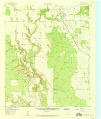
1959 Map of Girard
USGS Topo · Published 1960About this map
Girard serves as the primary hub of this West Texas landscape, positioned along the Fort Worth and Denver (Burlington) railroad line. This 1959 survey reveals a rural economy shaped by ranching and early petroleum exploration, with numerous oil wells and windmills like the North Whatley Windmill and North Floyd Windmill dotting the terrain. The community infrastructure is well-defined, featuring the Girard Cem and an Athletic Field within the town site, while the Rising Star Sch stands further south near the winding path of Dry Duck Creek. The drainage patterns of Duck Creek and its tributaries, including West Fork Duck Creek, dominate the topography, creating a series of breaks and draws. Local landmarks such as the VABM Okeefe 2130 and several gravel pits reflect the physical utility of the land during this mid-century period.
Find a feature on this map
24 named features on this map. Tap any name to fly to it.
Don’t see what you’re looking for? This feature index may not catch every label — zoom into the map to look around manually.
Map Details
Editions of this 1959 Girard Map
2 editions found
Other maps of this area

1954 · Lubbock
USGS Topo · 1:250,000

1958 · Pursley House
USGS Topo · 1:24,000

1958 · Jayton
USGS Topo · 1:24,000

1959 · Gilpin
USGS Topo · 1:24,000

1967 · Spur
USGS Topo · 1:24,000

1968 · White Camp
USGS Topo · 1:24,000

1969 · Clairemont East
USGS Topo · 1:24,000

1969 · Clairemont West
USGS Topo · 1:24,000

1969 · Jayton South
USGS Topo · 1:24,000
1985 · Aspermont
USGS Topo · 1:100,000