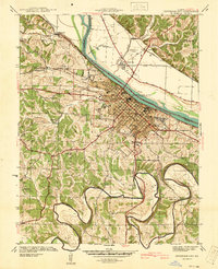
1939 Map of Jefferson City
USGS Topo · Published 1940About this map
The State Capitol and the riverfront of Jefferson City dominate the landscape in this late-1930s survey, illustrating the city's role as a political and institutional hub. The Missouri State Penitentiary occupies a significant tract along the Missouri River, while the State Prison Farm and Jefferson City Airport sit across the water in Callaway County. Educational and social institutions like the Lincoln Institute, St Marys Hospital, and numerous neighborhood schools such as West Sch and Park Sch indicate the city's established community structure. To the south, the terrain becomes more complex as the Moreau River carves the deep Moreau Bend, a contrast to the grid-heavy urban core. This area is dotted with rural landmarks including Zion Sch, East Union Sch, and family-named sites like Lamkin Cem and Shumate Cem.
Find a feature on this map
60 named features on this map. Tap any name to fly to it.
Don’t see what you’re looking for? This feature index may not catch every label — zoom into the map to look around manually.
Map Details
Editions of this 1939 Jefferson City Map
2 editions found
Other maps of this area

1886 · Jefferson City
USGS Topo · 1:125,000

1888 · Tuscumbia
USGS Topo · 1:125,000

1894 · Tuscumbia
USGS Topo · 1:125,000

1894 · Jefferson City
USGS Topo · 1:125,000

1939 · Jefferson City
USGS Topo · 1:24,000

1939 · Jefferson City
USGS Topo · 1:62,500

1942 · Jefferson City
USGS Topo · 1:62,500

1947 · Jefferson City
USGS Topo · 1:250,000

1948 · Centertown
USGS Topo · 1:62,500

1948 · Meta
USGS Topo · 1:62,500
Featured Places
- Jefferson City, MO
- Holts Summit, MO
- Wardsville, MO
- Cole Junction, Jefferson City
- North Jefferson, Jefferson City