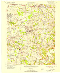
1955 Map of Jeffersontown
USGS Topo · Published 1956About this map
Jeffersontown and the surrounding Jefferson County landscape appear here in the mid-1950s, a period of transition as suburban expansion begins to reach into rural Kentucky. The map documents established communities like Lyndon, Middletown, and Fern Creek, while highlighting mid-century developments such as Cambridge Village and St Regis Park. The transportation network is a central focus, featuring the early path of the Henry Watterson Expressway and the long-standing tracks of the Southern Railway.
Find a feature on this map
42 named features on this map. Tap any name to fly to it.
Don’t see what you’re looking for? This feature index may not catch every label — zoom into the map to look around manually.
Map Details
Editions of this 1955 Jeffersontown Map
This is the sole edition of this map. No revisions or reprints were ever made.
Other maps of this area

1905 · Prospect
USGS Topo · 1:62,500

1907 · Louisville
USGS Topo · 1:62,500

1912 · Prospect
USGS Topo · 1:62,500

1929 · Taylorsville
USGS Topo · 1:62,500

1932 · La Grange
USGS Topo · 1:62,500

1937 · Jeffersonville
USGS Topo · 1:24,000

1946 · Jeffersonville
USGS Topo · 1:24,000

1951 · Anchorage
USGS Topo · 1:24,000

1951 · Crestwood
USGS Topo · 1:24,000
1951 · Jeffersonville
USGS Topo · 1:24,000