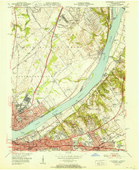
1951 Map of Jeffersonville
USGS Topo · Published 1951About this map
The Ohio River serves as the central artery between two growing industrial and residential hubs during the early 1950s. On the Indiana shore, the U S Military Reservation (Indiana Arsenal) occupies a significant portion of the Utica area, while Jeffersonville shows a dense grid of streets and public institutions like the Clark Memorial Hospital and Jeffersonville High Sch. Across the river in Kentucky, the map details the suburban expansion of Louisville, highlighting established neighborhoods such as Crescent Hill, Clifton, and St Matthews. This period captures the region's heavy reliance on rail and river transit, evidenced by the Big Four RR Bridge and the sprawling yards of the Pennsylvania and Baltimore and Ohio railroads. Notable social landmarks include the Kentucky School for the Blind and the Zachary Taylor National Cemetery, illustrating the diverse civic and military history of the Falls of the Ohio region.
Find a feature on this map
120 named features on this map. Tap any name to fly to it.
Don’t see what you’re looking for? This feature index may not catch every label — zoom into the map to look around manually.
Map Details
Editions of this 1951 Jeffersonville Map
This is the sole edition of this map. No revisions or reprints were ever made.
Other maps of this area

1905 · Prospect
USGS Topo · 1:62,500

1907 · Louisville
USGS Topo · 1:62,500

1909 · Kosmosdale
USGS Topo · 1:48,000

1912 · Prospect
USGS Topo · 1:62,500

1912 · Kosmosdale
USGS Topo · 1:62,500

1937 · Jeffersonville
USGS Topo · 1:24,000

1937 · Charlestown
USGS Topo · 1:24,000

1938 · Owen
USGS Topo · 1:24,000

1938 · Speed
USGS Topo · 1:24,000

1939 · New Albany
USGS Topo · 1:24,000