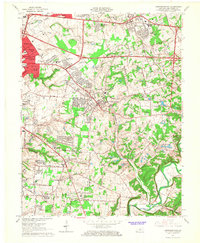
1964 Map of Jeffersontown
USGS Topo · Published 1967About this map
Jeffersontown serves as a central hub in this mid-century portrait of eastern Jefferson County, where suburban expansion is visibly encroaching upon a traditionally agrarian landscape. The eastern edge of Louisville is marked by burgeoning residential developments like St. Regis Park, Houston Acres, and Hurstbourne Acres, which contrast sharply with the winding watercourses of Chenoweth Run and Floyds Fork. The Southern Railway cuts through the center of the sheet, linking established centers like Middletown and Fern Creek to the broader regional economy.
Find a feature on this map
73 named features on this map. Tap any name to fly to it.
Don’t see what you’re looking for? This feature index may not catch every label — zoom into the map to look around manually.
Map Details
Editions of this 1964 Jeffersontown Map
2 editions found
Other maps of this area

1905 · Prospect
USGS Topo · 1:62,500

1907 · Louisville
USGS Topo · 1:62,500

1912 · Prospect
USGS Topo · 1:62,500

1929 · Taylorsville
USGS Topo · 1:62,500

1932 · La Grange
USGS Topo · 1:62,500

1937 · Jeffersonville
USGS Topo · 1:24,000

1946 · Jeffersonville
USGS Topo · 1:24,000

1951 · Anchorage
USGS Topo · 1:24,000

1951 · Crestwood
USGS Topo · 1:24,000
1951 · Jeffersonville
USGS Topo · 1:24,000