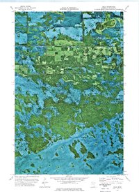
1973 Map of Jelle
USGS Topo · Published 1976About this map
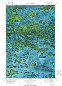
The Red Lake Indian Reservation dominates the southern landscape of this orthophotomap, showing the intricate natural drainage and marshy terrain of northern Minnesota in the early 1970s. This hybrid imagery, created from high-altitude aerial photography, captures the transition from the protected wetlands of the reservation to the managed conservation lands of the Hamre State Wildlife Management Area. The settlement of Jelle and the nearby Rice Field provide rare points of human habitation in a region defined by its vast hydrological patterns and dense forest cover. The orthophoto format is particularly useful here, as it reveals the precise texture of the vegetation and the subtle water channels across Lee and Hamre townships that traditional topographic line maps often simplify.
Find a feature on this map
7 named features on this map. Tap any name to fly to it.
Don’t see what you’re looking for? This feature index may not catch every label — zoom into the map to look around manually.
Map Details
Editions of this 1973 Jelle Map
This is the sole edition of this map. No revisions or reprints were ever made.
Other maps of this area

1918 · Malcolm
USGS Topo · 1:62,500

1918 · Jelle
USGS Topo · 1:62,500

1919 · Liner
USGS Topo · 1:62,500

1954 · Roseau
USGS Topo · 1:250,000

1957 · Roseau
USGS Topo · 1:250,000

1958 · Roseau
USGS Topo · 1:250,000
1972 · Good Lake
USGS Topo · 1:24,000
1973 · Grygla
USGS Topo · 1:24,000
1973 · Erie NE
USGS Topo · 1:24,000
1973 · Cahill Lake
USGS Topo · 1:24,000