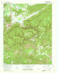
1970 Map of Jellico East
USGS Topo · Published 1972About this map
Pine Mountain dominates the landscape of this 1970 revision, cutting a massive diagonal across the terrain between the Tennessee and Kentucky border. The region's industrial character is defined by extensive surface mining, with numerous Strip Mine operations and a Quarry dotting the ridges above Hickory Creek and Clear Fork. Settlement patterns follow the narrow valley floors and the path of the Louisville and Nashville and Southern railroads, which served the coal and timber interests of the day. In the community of Jellico, the map details a high density of residential and commercial structures, including a High Sch and Crouches Creek Cem. Further south, rural life is marked by landmarks such as the Walnut Grove Ch and the Lookout Tower on Rich Mountain, illustrating a landscape where natural topography and industrial extraction coexist.
Find a feature on this map
62 named features on this map. Tap any name to fly to it.
Don’t see what you’re looking for? This feature index may not catch every label — zoom into the map to look around manually.
Map Details
Editions of this 1970 Jellico East Map
3 editions found
Other maps of this area

1886 · Cumberland Gap
USGS Topo · 1:125,000

1888 · Cumberland Gap
USGS Topo · 1:125,000

1890 · Williamsburg
USGS Topo · 1:125,000

1891 · Cumberland Gap
USGS Topo · 1:125,000

1893 · Briceville
USGS Topo · 1:125,000

1894 · Williamsburg
USGS Topo · 1:125,000

1895 · Briceville
USGS Topo · 1:125,000

1896 · Briceville
USGS Topo · 1:125,000

1897 · Maynardville
USGS Topo · 1:125,000

1900 · Maynardville
USGS Topo · 1:125,000