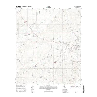
2015 Map of Jena West
USGS Topo · Published 2015About this map
Jena and its neighboring communities in LaSalle Parish are defined by a complex network of bayous and prongs that shaped the development of central Louisiana. This 2015 data illustrates a landscape where small settlements like Trout, Good Pine, and Belah remain connected by historical parish roads and state routes, centered around the commerce of the parish seat. The topography reveals how the terrain is etched by waterways such as Bayou Funny Louis and Trout Cr, which historically influenced local timber and agricultural activities. Genealogical interests are well-served by the documentation of numerous local burial grounds, including Mount Sinai Cem, Taylor Chapel Cem, and Forsyth Cem. The presence of the Jena Airport and the community at Webb Quarters provides further context for the modern infrastructure and residential patterns that have evolved from earlier rural clusters.
Find a feature on this map
132 named features on this map. Tap any name to fly to it.
Don’t see what you’re looking for? This feature index may not catch every label — zoom into the map to look around manually.
Map Details
Editions of this 2015 Jena West Map
This is the sole edition of this map. No revisions or reprints were ever made.
Other maps of this area

1936 · Pollock
USGS Topo · 1:62,500

1941 · Jena
USGS Topo · 1:62,500

1941 · Pollock
USGS Topo · 1:62,500

1953 · Alexandria
USGS Topo · 1:250,000

1954 · Tullos
USGS Topo · 1:62,500

1955 · Alexandria
USGS Topo · 1:250,000

1955 · Olla
USGS Topo · 1:62,500

1958 · Pollock
USGS Topo · 1:62,500

1958 · Jena
USGS Topo · 1:62,500
1984 · Summerville
USGS Topo · 1:24,000