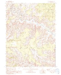
1991 Map of Jenny Canyon
USGS Topo · Published 1991About this map
The Price River carves a deeply entrenched, meandering path through this high desert landscape, defining the northern geography of the area. This 1991 provisional survey highlights the significant elevation changes between the river valley and the massive landforms that dominate the central and eastern portions of the map, including the Beckwith Plateau and Elliott Mesa. A network of 4WD roads and primitive trails provides the only access into these remote reaches of Emery County, tracing the high ridges of the Big Horn Benches and the steep slopes of Big Horn Mountain. The drainage patterns are clearly defined by numerous named features such as Jenny Canyon, Long Canyon, and Sand Knolls Canyon, illustrating how water has sculpted the plateau over time.
Find a feature on this map
12 named features on this map. Tap any name to fly to it.
Don’t see what you’re looking for? This feature index may not catch every label — zoom into the map to look around manually.
Map Details
Editions of this 1991 Jenny Canyon Map
This is the sole edition of this map. No revisions or reprints were ever made.
Other maps of this area

1886 · Price River
USGS Topo · 1:250,000

1896 · Price River
USGS Topo · 1:250,000

1948 · Woodside
USGS Topo · 1:62,500

1949 · Woodside
USGS Topo · 1:62,500

1950 · Woodside
USGS Topo · 1:62,500

1954 · Range Creek
USGS Topo · 1:62,500

1956 · Price
USGS Topo · 1:250,000

1960 · Price
USGS Topo · 1:250,000

1962 · Price
USGS Topo · 1:250,000
1963 · Gunnison Butte
USGS Topo · 1:62,500