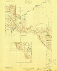
1910 Map of Jensen
USGS Topo · Published 1940About this map
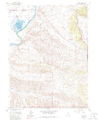
The Green River carves a dramatic path through this high-desert landscape, dominated by the uplift of Split Mtn and the early boundaries of Dinosaur National Monument. Surveyed in 1907, the map captures the isolated settlements of the Ashley Valley, where Vernal and Naples served as the primary hubs for regional ranching and agriculture. The reliance on river crossings is evident near Jensen, where a Ferry provided a vital link across the water. To the south and east, the terrain is defined by massive geologic features like The Rim Rock and Cliff Ridge, transitioning toward the Colorado border. The presence of Asphalt Ridge and named outposts like K Ranch reflect an era of early natural resource identification and wide-ranging livestock operations in the Uintah Basin.
Find a feature on this map
27 named features on this map. Tap any name to fly to it.
Don’t see what you’re looking for? This feature index may not catch every label — zoom into the map to look around manually.
Map Details
Editions of this 1910 Jensen Map
2 editions found

Historical Maps of Vernal Through Time
8 maps found