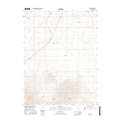
2017 Map of Jericho
USGS Topo · Published 2017About this map
Jericho serves as a lone settlement point in this high-desert landscape of western Utah, situated where the Union Pacific Rd cuts through the broad expanse of the Tintic Valley. The terrain transition is sharp, as the flat valley floor meets the northern reaches of the Gilson Mountains, which dominate the southern half of the sheet with steep elevation gains. Drainage in this arid environment is represented by ephemeral features such as Wash Canyon and the seasonal path of Tanner Cr to the northwest. The infrastructure reflects the area's isolation and utility, defined by a sparse network of tracks including Gilson Basin Rd and the long, straight stretches of Rte 1812. This survey illustrates the spatial relationship between the historic rail corridor and the natural barriers that directed travel and transport through Juab County.
Find a feature on this map
15 named features on this map. Tap any name to fly to it.
Don’t see what you’re looking for? This feature index may not catch every label — zoom into the map to look around manually.
Map Details
Editions of this 2017 Jericho Map
This is the sole edition of this map. No revisions or reprints were ever made.
Other maps of this area

1885 · Sevier Desert
USGS Topo · 1:250,000

1953 · Delta
USGS Topo · 1:250,000

1954 · Mc Intyre
USGS Topo · 1:24,000

1954 · Tintic Mountain
USGS Topo · 1:24,000

1958 · Delta
USGS Topo · 1:250,000

1962 · Delta
USGS Topo · 1:250,000

1962 · Lynndyl
USGS Topo · 1:62,500

1963 · Maple Peak
USGS Topo · 1:24,000

1967 · Champlin Peak
USGS Topo · 1:24,000
1967 · Furner Ridge
USGS Topo · 1:24,000