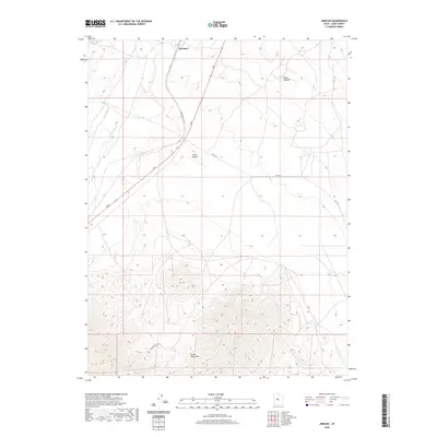
2020 Map of Jericho
USGS Topo · Published 2020About this map
Jericho sits as a lonely point of reference in this arid reach of Juab County, defined by the transport corridor of the Union Pacific Rd. This modern survey illustrates the rugged southern terminus of the Tintic Valley, where the open basin gives way to the prominent elevations of the Gilson Mountains. The drainage of Tanner Cr and the deep incision of Wash Canyon mark the topography, while a sparse network of routes like Rte 1812 and Gilson Basin Rd provide the only access across the high desert terrain. The landscape is dominated by wide-open spaces and steep contour gradients, offering a clear view of the geographic isolation and infrastructure required to navigate this portion of the Great Basin.
Find a feature on this map
9 named features on this map. Tap any name to fly to it.
Don’t see what you’re looking for? This feature index may not catch every label — zoom into the map to look around manually.
Map Details
Editions of this 2020 Jericho Map
This is the sole edition of this map. No revisions or reprints were ever made.
Other maps of this area

1885 · Sevier Desert
USGS Topo · 1:250,000

1953 · Delta
USGS Topo · 1:250,000

1954 · Mc Intyre
USGS Topo · 1:24,000

1954 · Tintic Mountain
USGS Topo · 1:24,000

1958 · Delta
USGS Topo · 1:250,000

1962 · Delta
USGS Topo · 1:250,000

1962 · Lynndyl
USGS Topo · 1:62,500

1963 · Maple Peak
USGS Topo · 1:24,000

1967 · Champlin Peak
USGS Topo · 1:24,000
1967 · Furner Ridge
USGS Topo · 1:24,000