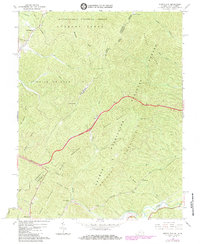
1966 Map of Jerrys Run
USGS Topo · Published 1984About this map
George Washington National Forest and Monongahela National Forest converge on this terrain along the border of West Virginia and Virginia. The landscape is dominated by the steep ridges of Brushy Mountain and Lewis Mountain, which created significant engineering challenges for mid-century transportation networks. The Chesapeake and Ohio railroad corridor is particularly notable here, featuring a series of major subterranean works including the Lewis Tunnels, Kelly Tunnel, Lake Tunnel, and Moore Tunnel.
Find a feature on this map
45 named features on this map. Tap any name to fly to it.
Don’t see what you’re looking for? This feature index may not catch every label — zoom into the map to look around manually.
Map Details
Editions of this 1966 Jerrys Run Map
2 editions found
Other maps of this area

1887 · Lewisburg
USGS Topo · 1:125,000

1891 · Lewisburg
USGS Topo · 1:125,000

1921 · Callaghan
USGS Topo · 1:48,000

1921 · White Sulphur Springs
USGS Topo · 1:48,000

1921 · Ronceverte
USGS Topo · 1:48,000

1923 · White Sulphur Springs
USGS Topo · 1:62,500

1923 · Ronceverte
USGS Topo · 1:62,500

1923 · Callaghan
USGS Topo · 1:62,500

1935 · White Sulphur Springs
USGS Topo · 1:62,500

1939 · White Sulphur Springs
USGS Topo · 1:62,500