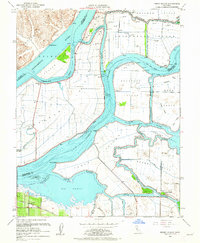
1952 Map of Jersey Island
USGS Topo · Published 1962About this map
Jersey Island and the surrounding reclaimed lands of the Sacramento-San Joaquin River Delta appear here in a complex network of levees, sloughs, and tracts. This mid-century survey captures the region's intricate water management system, showing numerous pump houses and tide gages necessary for maintaining these low-lying agricultural and residential areas. The Atchison Topeka and Santa Fe railroad skirts the southern edge of the map, providing a vital connection to the mainland across the marshy terrain of Big Break. On Bethel Island, a developing road network including Sunset Drive and Gateway Road suggests the transition toward recreational and residential use. The landscape is defined by its deep-water channels, including the Sacramento River and San Joaquin River, which isolate large landmasses like the Webb Tract and Bradford Island, accessible only by ferry or watercraft at the time of this survey.
Find a feature on this map
48 named features on this map. Tap any name to fly to it.
Don’t see what you’re looking for? This feature index may not catch every label — zoom into the map to look around manually.
Map Details
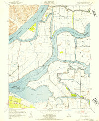
Editions of this 1952 Jersey Island Map
3 editions found
Historical Maps of Oakley Through Time
71 maps found

1902 Fairoaks
Sacramento County, CA

1908 Buffalo Creek
Sacramento County, CA

1909 Carbondale
Sacramento County, CA

1909 Cosumnes
Sacramento County, CA

1909 Goose Creek
Sacramento County, CA

1910 Bruceville
Sacramento County, CA

1910 Jersey
Sacramento County, CA

1911 Arcade
Sacramento County, CA

1911 Brighton
Sacramento County, CA

1911 Mills
Sacramento County, CA

1915 Elkhorn Weir
Sacramento County, CA

1916 Buffalo Creek
Sacramento County, CA

1916 Vorden
Sacramento County, CA

1941 Franklin
Sacramento County, CA

1949 Sacramento East
Sacramento County, CA

1950 Taylor Monument
Sacramento County, CA

1951 Taylor Monument
Sacramento County, CA

1952 Jersey Island
Sacramento County, CA

1953 Bruceville
Sacramento County, CA

1953 Carbondale
Sacramento County, CA

1953 Goose Creek
Sacramento County, CA

1953 Sloughhouse
Sacramento County, CA

1954 Buffalo Creek
Sacramento County, CA

1954 Folsom SE
Sacramento County, CA

1954 Sacramento East
Sacramento County, CA

1967 Buffalo Creek
Sacramento County, CA

1967 Sacramento East
Sacramento County, CA

1967 Taylor Monument
Sacramento County, CA

1968 Bruceville
Sacramento County, CA

1968 Carbondale
Sacramento County, CA

1968 Goose Creek
Sacramento County, CA

1968 Sloughhouse
Sacramento County, CA

1978 Jersey Island
Sacramento County, CA

1992 Sacramento East
Sacramento County, CA

1997 Goose Creek
Sacramento County, CA

2012 Bruceville
Sacramento County, CA

2012 Buffalo Creek
Sacramento County, CA

2012 Carbondale
Sacramento County, CA

2012 Folsom SE
Sacramento County, CA

2012 Goose Creek
Sacramento County, CA

2012 Jersey Island
Sacramento County, CA

2012 Sacramento East
Sacramento County, CA

2012 Sloughhouse
Sacramento County, CA

2012 Taylor Monument
Sacramento County, CA

2015 Bruceville
Sacramento County, CA

2015 Buffalo Creek
Sacramento County, CA

2015 Carbondale
Sacramento County, CA

2015 Folsom SE
Sacramento County, CA

2015 Goose Creek
Sacramento County, CA

2015 Jersey Island
Sacramento County, CA

2015 Sacramento East
Sacramento County, CA

2015 Sloughhouse
Sacramento County, CA

2015 Taylor Monument
Sacramento County, CA

2018 Bruceville
Sacramento County, CA

2018 Buffalo Creek
Sacramento County, CA

2018 Carbondale
Sacramento County, CA

2018 Folsom SE
Sacramento County, CA

2018 Goose Creek
Sacramento County, CA

2018 Jersey Island
Sacramento County, CA

2018 Sacramento East
Sacramento County, CA

2018 Sloughhouse
Sacramento County, CA

2018 Taylor Monument
Sacramento County, CA

2021 Bruceville
Sacramento County, CA

2021 Buffalo Creek
Sacramento County, CA

2021 Jersey Island
Sacramento County, CA

2021 Sacramento East
Sacramento County, CA

2021 Taylor Monument
Sacramento County, CA

2022 Carbondale
Sacramento County, CA

2022 Folsom SE
Sacramento County, CA

2022 Goose Creek
Sacramento County, CA

2022 Sloughhouse
Sacramento County, CA