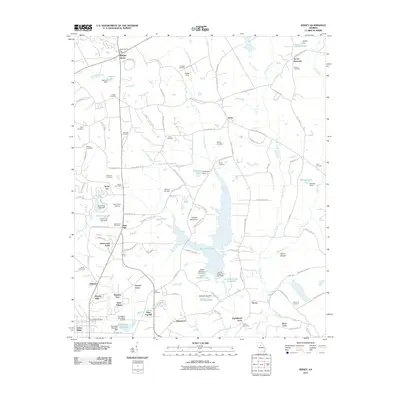
2011 Map of Jersey
USGS Topo · Published 2011About this map
Walnut Grove and the town of Jersey anchor this landscape during a period of transition, where small rural communities began expanding into more structured residential developments. The area is defined by its complex network of water resources and small aviation hubs, including Poole Farm Airport and the Covington Municipal Airport. Significant water bodies such as Cornish Creek Reservoir, Williams Lake, and the winding Alcovy River shape the local geography, with several dams like Hodges Dam and Whitley Dam managing the flow. Local history is deeply embedded in the land through numerous family and community burial grounds, such as Macedonia Cemetery, Forrester Cemetery, and Dally Cemetery. Notable elevations like Alcovy Mountain and Cornish Mountain provide distinct vertical relief against the creek basins, while small enclaves like Meadow View and Hazelbrand Acres reflect the modern growth surrounding these traditional Georgia settlements.
Find a feature on this map
126 named features on this map. Tap any name to fly to it.
Don’t see what you’re looking for? This feature index may not catch every label — zoom into the map to look around manually.
Map Details
Editions of this 2011 Jersey Map
This is the sole edition of this map. No revisions or reprints were ever made.
Other maps of this area

1896 · Monroe
USGS Topo · 1:125,000

1953 · Athens
USGS Topo · 1:250,000

1958 · Athens
USGS Topo · 1:250,000

1959 · Athens
USGS Topo · 1:250,000

1963 · Athens
USGS Topo · 1:250,000
1964 · Loganville
USGS Topo · 1:24,000

1964 · Between
USGS Topo · 1:24,000

1964 · Monroe
USGS Topo · 1:24,000

1964 · Porterdale
USGS Topo · 1:24,000

1964 · Covington
USGS Topo · 1:24,000