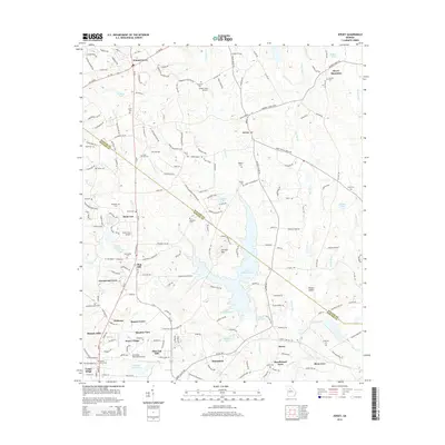
2014 Map of Jersey
USGS Topo · Published 2014About this map
Walnut Grove and Jersey anchor this 2014 survey of the borderlands between Walton and Newton Counties, a region characterized by dispersed residential communities and significant water features. The Alcovy River and Cornish Cr drain the landscape, feeding into a series of reservoirs and lakes including Wallace Lake, Upper Williams Lake, and Lower Williams Lake. Prominent elevations like Alcovy Mountain and Cornish Mtn rise above the drainage basins, while Hinton Shoals marks a distinct point along the river's path.
Find a feature on this map
70 named features on this map. Tap any name to fly to it.
Don’t see what you’re looking for? This feature index may not catch every label — zoom into the map to look around manually.
Map Details
Editions of this 2014 Jersey Map
This is the sole edition of this map. No revisions or reprints were ever made.
Other maps of this area

1896 · Monroe
USGS Topo · 1:125,000

1953 · Athens
USGS Topo · 1:250,000

1958 · Athens
USGS Topo · 1:250,000

1959 · Athens
USGS Topo · 1:250,000

1963 · Athens
USGS Topo · 1:250,000
1964 · Loganville
USGS Topo · 1:24,000

1964 · Between
USGS Topo · 1:24,000

1964 · Monroe
USGS Topo · 1:24,000

1964 · Porterdale
USGS Topo · 1:24,000

1964 · Covington
USGS Topo · 1:24,000