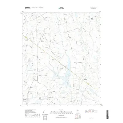
2020 Map of Jersey
USGS Topo · Published 2020About this map
Covington and the surrounding borderlands of Walton and Newton counties are defined by a complex network of reservoirs and family cemeteries in this modern topographic survey. The landscape is anchored by the Cornish Cr Reservoir, which feeds into Lower Williams Lake and Upper Williams Lake, illustrating the sophisticated water management systems central to this part of Georgia. High points like Alcovy Mountain and Cornish Mtn provide topographic relief above the river valleys, where Hinton Shoals marks a distinct point on the Alcovy River. This map is particularly valuable for genealogists, as it meticulously labels numerous small burial grounds, including the Carter Family Cem, Harris Family Cem, and the Chapman Family Cem. Regional transportation and infrastructure are represented by the Covington Municipal Airport and the sprawling residential developments emerging near Walnut Grove and Jersey.
Find a feature on this map
167 named features on this map. Tap any name to fly to it.
Don’t see what you’re looking for? This feature index may not catch every label — zoom into the map to look around manually.
Map Details
Editions of this 2020 Jersey Map
This is the sole edition of this map. No revisions or reprints were ever made.
Other maps of this area

1896 · Monroe
USGS Topo · 1:125,000

1953 · Athens
USGS Topo · 1:250,000

1958 · Athens
USGS Topo · 1:250,000

1959 · Athens
USGS Topo · 1:250,000

1963 · Athens
USGS Topo · 1:250,000
1964 · Loganville
USGS Topo · 1:24,000

1964 · Between
USGS Topo · 1:24,000

1964 · Monroe
USGS Topo · 1:24,000

1964 · Porterdale
USGS Topo · 1:24,000

1964 · Covington
USGS Topo · 1:24,000