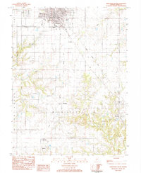
1983 Map of Jerseyville South
USGS Topo · Published 1984About this map
Jerseyville serves as the primary hub of this landscape, situated at the junction of several townships including English, Fidelity, and Otter Creek. The map documents the mid-century transition of the local economy, shown through the path of the Illinois Central Gulf railroad and the persisting Old Railroad Grade that cuts south toward McClusky. Rural life is anchored by small settlements like Dow and Newbern, alongside several family-named burial grounds such as Lamb Memorial Cem and Lurton Cem.
Find a feature on this map
36 named features on this map. Tap any name to fly to it.
Don’t see what you’re looking for? This feature index may not catch every label — zoom into the map to look around manually.
Map Details
Editions of this 1983 Jerseyville South Map
This is the sole edition of this map. No revisions or reprints were ever made.
Other maps of this area

1925 · Brighton
USGS Topo · 1:62,500

1927 · Alton
USGS Topo · 1:62,500

1927 · St. Charles
USGS Topo · 1:62,500

1928 · Brighton
USGS Topo · 1:62,500

1930 · Jerseyville
USGS Topo · 1:62,500

1933 · Jerseyville
USGS Topo · 1:62,500

1933 · Saint Charles
USGS Topo · 1:62,500

1934 · Alton
USGS Topo · 1:62,500

1948 · Quincy
USGS Topo · 1:250,000
1948 · Alton
USGS Topo · 1:24,000