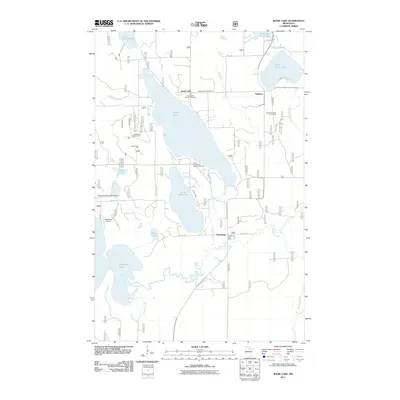
2011 Map of Jessie Lake
USGS Topo · Published 2011About this map
Jessie Lake and its surrounding northern Minnesota woodlands define this landscape, where small settlements and seasonal retreats congregate near the water's edge. The community of Talmoon sits at the junction of local routes north of the lake, while the Bowstring Post Office serves the southern area near the winding Bowstring River. Genealogical interest is found at the Old Norwegian Church Cemetery and Greenwood Cemetery, which reflect the early ethnic settlement patterns of Itasca County. The presence of the Jessie Lake Lookout Tower and several remote airstrips like the Bowstring Municipal Airport suggest a landscape managed for timber resources and outdoor recreation. Waterways such as Jessie Brook and the Turtle River connect a series of smaller basins, including Little Jessie Lake and Little Turtle Lake, forming a complex drainage network typical of this lake-studded region.
Find a feature on this map
40 named features on this map. Tap any name to fly to it.
Don’t see what you’re looking for? This feature index may not catch every label — zoom into the map to look around manually.
Map Details
Editions of this 2011 Jessie Lake Map
This is the sole edition of this map. No revisions or reprints were ever made.
Other maps of this area

1919 · Marcell
USGS Topo · 1:62,500

1954 · Hibbing
USGS Topo · 1:250,000

1957 · Hibbing
USGS Topo · 1:250,000

1958 · Hibbing
USGS Topo · 1:250,000

1964 · Hibbing
USGS Topo · 1:250,000

1970 · Bowstring Lake
USGS Topo · 1:24,000

1970 · Deer River NE
USGS Topo · 1:24,000

1970 · Jessie Lake
USGS Topo · 1:24,000
1970 · Little Bowstring Lake
USGS Topo · 1:24,000
1970 · Little Ball Club Lake
USGS Topo · 1:24,000