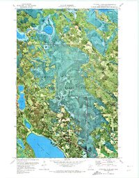
1970 Map of Little Ball Club Lake
USGS Topo · Published 1973About this map
Chippewa National Forest and Bowstring State Forest define this 1970s orthophotomap, which uses aerial imagery to show the intricate waterways and wetland fringes of North Central Minnesota. The landscape is dominated by the massive Ball Club Lake to the south and Bowstring Lake in the northeast, connected by a network of drainage including the First River. Unlike standard topographic maps, this orthophoto provides a direct photographic view of the dense forest cover and marshy transitions around smaller water bodies like Little Ball Club Lake, Tuttle Lake, and Egg Lake. Cultural landmarks are sparse in this protected wilderness, though the location of Salem Chapel is clearly noted along the road network on the eastern edge of the quadrangle, serving as a rare focal point for local history in this heavily forested region.
Find a feature on this map
12 named features on this map. Tap any name to fly to it.
Don’t see what you’re looking for? This feature index may not catch every label — zoom into the map to look around manually.
Map Details
Editions of this 1970 Little Ball Club Lake Map
This is the sole edition of this map. No revisions or reprints were ever made.
Other maps of this area

1919 · Max
USGS Topo · 1:62,500

1954 · Bemidji
USGS Topo · 1:250,000

1954 · Hibbing
USGS Topo · 1:250,000

1957 · Bemidji
USGS Topo · 1:250,000

1957 · Hibbing
USGS Topo · 1:250,000

1958 · Bemidji
USGS Topo · 1:250,000

1958 · Hibbing
USGS Topo · 1:250,000

1964 · Hibbing
USGS Topo · 1:250,000

1970 · Bowstring Lake
USGS Topo · 1:24,000

1970 · Deer River NE
USGS Topo · 1:24,000