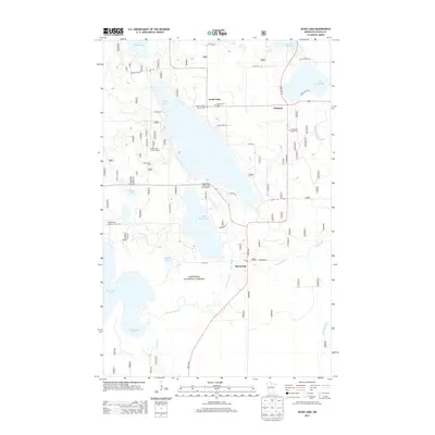
2013 Map of Jessie Lake
USGS Topo · Published 2013About this map
Chippewa National Forest defines the lake-studded landscape of north-central Minnesota, where the settlement of Talmoon and the community of Bowstring serve as local hubs. This area is characterized by a dense network of glacial water bodies, including the expansive Jessie Lake and Little Jessie Lake, which are linked by the winding Jessie Brook and the Bowstring River. Historical and genealogical markers are scattered throughout the timberland, such as the Old Norwegian Church Cem, Greenwood Cem, and Evergreen Knoll Cem. The map reflects a local economy rooted in outdoor recreation and forestry, evidenced by the Jessie View Resort and Campground and the Jessie Lake Lookout Tower. Infrastructure like the Bowstring Airport and the Jessie Lake Pit near Elbow Lake point to the area's logistical and industrial facets amidst the surrounding wilderness.
Find a feature on this map
39 named features on this map. Tap any name to fly to it.
Don’t see what you’re looking for? This feature index may not catch every label — zoom into the map to look around manually.
Map Details
Editions of this 2013 Jessie Lake Map
This is the sole edition of this map. No revisions or reprints were ever made.
Other maps of this area

1919 · Marcell
USGS Topo · 1:62,500

1954 · Hibbing
USGS Topo · 1:250,000

1957 · Hibbing
USGS Topo · 1:250,000

1958 · Hibbing
USGS Topo · 1:250,000

1964 · Hibbing
USGS Topo · 1:250,000

1970 · Bowstring Lake
USGS Topo · 1:24,000

1970 · Deer River NE
USGS Topo · 1:24,000

1970 · Jessie Lake
USGS Topo · 1:24,000
1970 · Little Bowstring Lake
USGS Topo · 1:24,000
1970 · Little Ball Club Lake
USGS Topo · 1:24,000