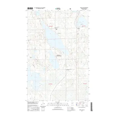
2016 Map of Jessie Lake
USGS Topo · Published 2016About this map
Chippewa National Forest surrounds a dense network of glacial lakes and wetlands in Itasca County, defining the rural character of this northern Minnesota landscape. Settlement is concentrated around the larger water bodies, with the communities of Jessie Lake, Talmoon, and Bowstring serving as local hubs. Genealogists will find three distinct burial grounds in this area: Old Norwegian Church Cem and Greenwood Cem near the northern shore of Jessie Lake, and Evergreen Knoll Cem located further east near Talmoon.
Find a feature on this map
41 named features on this map. Tap any name to fly to it.
Don’t see what you’re looking for? This feature index may not catch every label — zoom into the map to look around manually.
Map Details
Editions of this 2016 Jessie Lake Map
This is the sole edition of this map. No revisions or reprints were ever made.
Other maps of this area

1919 · Marcell
USGS Topo · 1:62,500

1954 · Hibbing
USGS Topo · 1:250,000

1957 · Hibbing
USGS Topo · 1:250,000

1958 · Hibbing
USGS Topo · 1:250,000

1964 · Hibbing
USGS Topo · 1:250,000

1970 · Bowstring Lake
USGS Topo · 1:24,000

1970 · Deer River NE
USGS Topo · 1:24,000

1970 · Jessie Lake
USGS Topo · 1:24,000
1970 · Little Bowstring Lake
USGS Topo · 1:24,000
1970 · Little Ball Club Lake
USGS Topo · 1:24,000