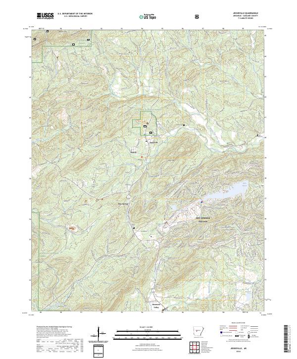
2024 Map of Jessieville
USGS Topo · Published 2024About this map
Hot Springs Village dominates the eastern landscape of this modern survey, revealing a complex network of residential streets and man-made water bodies such as Lake Desoto and Lake Segovia. This planned community contrasts sharply with the western half of the map, which is largely defined by the protected lands of the Ouachita National Forest. Smaller, long-established settlements like Jessieville and Blakely sit at the intersection of local routes, while the southern reaches near Mountain Valley show the winding paths of Glazypeau Creek and Cedar Creek. For local historians and genealogists, the map identifies key burial sites including Shiloh Cemetery, Cosby Cemetery, and Newkirk Cemetery, providing essential markers of the area's rural heritage. The terrain transitions from the elevations of Short Mountain and Cedar Mountain to the active waterways of the Middle Fork Saline River, illustrating the topographical shift between the high ridges and the residential developments that have reshaped the Garland County forestland.
Find a feature on this map
45 named features on this map. Tap any name to fly to it.
Don’t see what you’re looking for? This feature index may not catch every label — zoom into the map to look around manually.
Map Details
Editions of this 2024 Jessieville Map
This is the sole edition of this map. No revisions or reprints were ever made.
Other maps of this area

1890 · Benton
USGS Topo · 1:125,000

1890 · Hot Springs
USGS Topo · 1:125,000

1894 · Hot Springs
USGS Topo · 1:125,000

1894 · Benton
USGS Topo · 1:125,000

1955 · Little Rock
USGS Topo · 1:250,000

1956 · Little Rock
USGS Topo · 1:250,000

1960 · Little Rock
USGS Topo · 1:250,000

1963 · Paron SW
USGS Topo · 1:24,000

1964 · Little Rock
USGS Topo · 1:250,000
1966 · Hot Springs North
USGS Topo · 1:24,000