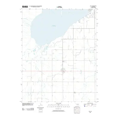
2009 Map of Jet
USGS Topo · Published 2009About this map
The town of Jet serves as the focal point of this northern Oklahoma landscape, situated just south of the expansive Great Salt Plains Reservoir. This 2009 survey by the U.S. Geological Survey illustrates the intersection of intensive agriculture and major water management, with the Salt Fork Arkansas River feeding the reservoir behind the Great Salt Plains Dam. The surrounding terrain is defined by a systematic grid of section roads like E0230 Rd and N2720 Rd that navigate several drainage systems, including Wagon Creek and Twin Spring Creek. Genealogists and local historians will find several burial sites recorded across the township, such as Pleasant View Cemetery, Milan Valley Cemetery, and Thrawl Cemetery, which provide clues to the settlement patterns of Alfalfa County.
Find a feature on this map
26 named features on this map. Tap any name to fly to it.
Don’t see what you’re looking for? This feature index may not catch every label — zoom into the map to look around manually.
Map Details
Editions of this 2009 Jet Map
This is the sole edition of this map. No revisions or reprints were ever made.
Other maps of this area

1955 · Woodward
USGS Topo · 1:250,000

1958 · Woodward
USGS Topo · 1:250,000

1969 · Jet
USGS Topo · 1:24,000

1969 · Goltry
USGS Topo · 1:24,000

1969 · Nash
USGS Topo · 1:24,000

1969 · Helena
USGS Topo · 1:24,000
1969 · Sand Creek
USGS Topo · 1:24,000

1969 · Manchester SW
USGS Topo · 1:24,000

1969 · Cherokee North
USGS Topo · 1:24,000

1969 · Jet SE
USGS Topo · 1:24,000