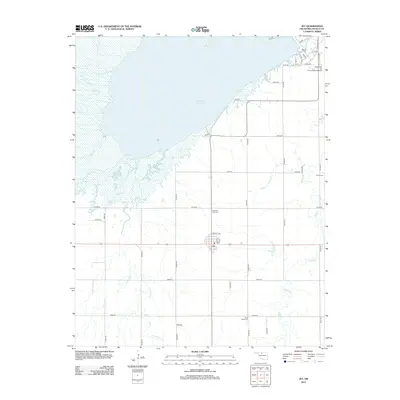
2012 Map of Jet
USGS Topo · Published 2012About this map
The town of Jet serves as the focal point of this Alfalfa County study, situated just south of the sprawling Great Salt Plains Reservoir. The landscape is defined by the hydrologic network of Spring Cr, Twin Spring Cr, and Wagon Cr that drains toward the reservoir's marshy edges. In the northeastern corner, the Kegelman Air Force Auxiliary Field marks a significant military presence, with a detailed grid of access roads like p10 RD and p11 RD serving the facility. For those tracing local history and family lineages, several burial grounds are scattered throughout the rural sections, including Pleasant View Cem north of town and Milan Valley Cem to the southeast. The map reflects a typical Great Plains agricultural layout, where the section-line road system creates a rigid framework for the homesteads and farms surrounding the central hub of Jet.
Find a feature on this map
40 named features on this map. Tap any name to fly to it.
Don’t see what you’re looking for? This feature index may not catch every label — zoom into the map to look around manually.
Map Details
Editions of this 2012 Jet Map
This is the sole edition of this map. No revisions or reprints were ever made.
Other maps of this area

1955 · Woodward
USGS Topo · 1:250,000

1958 · Woodward
USGS Topo · 1:250,000

1969 · Jet
USGS Topo · 1:24,000

1969 · Goltry
USGS Topo · 1:24,000

1969 · Nash
USGS Topo · 1:24,000

1969 · Helena
USGS Topo · 1:24,000
1969 · Sand Creek
USGS Topo · 1:24,000

1969 · Manchester SW
USGS Topo · 1:24,000

1969 · Cherokee North
USGS Topo · 1:24,000

1969 · Jet SE
USGS Topo · 1:24,000