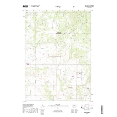
2017 Map of Jewel Cave SE
USGS Topo · Published 2017About this map
Black Hills National Forest land dominates this section of Custer County, revealing a landscape defined by its vital water sources and forest management infrastructure. Numerous named springs, including Issue Wood Spring, Rogers Shack Spring, and Nitche Spring, are scattered throughout the terrain, suggesting their historical importance for wildlife and early travelers in this arid region. The map documents an extensive network of Forest Service roads and trails, such as the Hawkwright Loop and Richardson Well Br 1D, which facilitate access through the timbered hills and meadows. Notable topographic landmarks like Red Cliff and Hawkwright Vista overlook drainage systems like Pass Creek and the E Fork Hawkwright Cr. In the southeastern corner, the deep incision of Red Canyon provides a stark contrast to the higher elevation features like Elk Meadow, illustrating the diverse geography of the Black Hills south of Jewel Cave.
Find a feature on this map
91 named features on this map. Tap any name to fly to it.
Don’t see what you’re looking for? This feature index may not catch every label — zoom into the map to look around manually.
Map Details
Editions of this 2017 Jewel Cave SE Map
This is the sole edition of this map. No revisions or reprints were ever made.
Other maps of this area

1896 · Harney Peak
USGS Topo · 1:125,000

1901 · Harney Peak
USGS Topo · 1:125,000

1902 · Edgemont
USGS Topo · 1:125,000

1950 · Burdock
USGS Topo · 1:24,000

1950 · Edgemont NE
USGS Topo · 1:24,000

1950 · Minnekahta
USGS Topo · 1:24,000

1954 · Fourmile
USGS Topo · 1:24,000

1954 · Jewel Cave SE
USGS Topo · 1:24,000
1954 · Jewel Cave SW
USGS Topo · 1:24,000

1955 · Jewel Cave NW
USGS Topo · 1:24,000