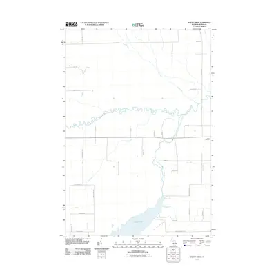
2011 Map of Jewett Creek
USGS Topo · Published 2011About this map
Fletcher Pond and its sprawling northern marshlands dominate this landscape in Alpena and Montmorency counties, highlighting a region defined by complex water systems. The Thunder Bay River meanders across the center of the sheet, joined by the Upper South Branch Thunder Bay River and the smaller Jewett Creek. This hydraulic network historically supported the timber and recreation economies of Northern Michigan, evident here through the numerous access points like Emils Landing Rd and Jacks Landing Rd. Local genealogy and land use are preserved in the naming of rural routes such as Doyle School Rd and Taylor Hawks Rd, while Green Cemetery provides a fixed point of local history near the eastern boundary. The grid of roads, including Long Rapids Rd, cuts through a terrain of creeks and wetlands, including Truax Creek in the north.
Find a feature on this map
38 named features on this map. Tap any name to fly to it.
Don’t see what you’re looking for? This feature index may not catch every label — zoom into the map to look around manually.
Map Details
Editions of this 2011 Jewett Creek Map
This is the sole edition of this map. No revisions or reprints were ever made.
Other maps of this area

1954 · Tawas City
USGS Topo · 1:250,000

1954 · Alpena
USGS Topo · 1:250,000

1955 · Hillman
USGS Topo · 1:62,500

1957 · Alpena
USGS Topo · 1:250,000

1958 · Alpena
USGS Topo · 1:250,000

1958 · Tawas City
USGS Topo · 1:250,000

1969 · Alpena
USGS Topo · 1:250,000

1971 · Polaski
USGS Topo · 1:24,000

1971 · Lachine
USGS Topo · 1:24,000
1972 · Beaver Lake
USGS Topo · 1:24,000