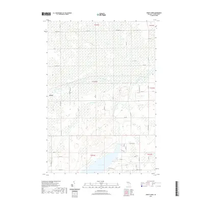
2019 Map of Jewett Creek
USGS Topo · Published 2019About this map
Hillman occupies the western edge of this Alpena County landscape, where the Thunder Bay River winds through a complex system of northern Michigan wetlands. The drainage of this area is largely defined by the Upper South Branch Thunder Bay River and its various tributaries, including Jewett Cr and Triax Cr. To the north, the terrain is dominated by the sprawling Long Swamp, while the southern portion of the map is significantly altered by the presence of Fletcher Pond, a large reservoir that has redefined the local hydrology. The road network, including Doyle School Rd and Jacks Landing Rd, provides access to several interior water bodies like Sylvester Lake and Coombs Lake, reflecting the region's importance for water management and recreation. The transition from large-scale swamp and reservoir environments to the village of Hillman illustrates the varying ways water has shaped the development of this rural county.
Find a feature on this map
53 named features on this map. Tap any name to fly to it.
Don’t see what you’re looking for? This feature index may not catch every label — zoom into the map to look around manually.
Map Details
Editions of this 2019 Jewett Creek Map
This is the sole edition of this map. No revisions or reprints were ever made.
Other maps of this area

1954 · Tawas City
USGS Topo · 1:250,000

1954 · Alpena
USGS Topo · 1:250,000

1955 · Hillman
USGS Topo · 1:62,500

1957 · Alpena
USGS Topo · 1:250,000

1958 · Alpena
USGS Topo · 1:250,000

1958 · Tawas City
USGS Topo · 1:250,000

1969 · Alpena
USGS Topo · 1:250,000

1971 · Polaski
USGS Topo · 1:24,000

1971 · Lachine
USGS Topo · 1:24,000
1972 · Beaver Lake
USGS Topo · 1:24,000