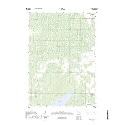
2023 Map of Jewett Creek
USGS Topo · Published 2023About this map
Fletcher Pond dominates the southern reaches of this Alpena County landscape, where the waters of the Upper South Branch Thunder Bay River collect before flowing north. The terrain is defined by a complex network of wetlands and tributaries, including the extensive Long Swamp and the winding course of Jewett Creek. A significant corridor for transit and recreation is formed by the Hillman-Alpena State Trl, which cuts a straight path across the central section of the township. In the northeastern portion, several small bodies of water like Coombs Lake are surrounded by a grid of rural routes including Salina Rd and Doyle School Rd, reflecting the persistent agricultural and residential structure of this northern Michigan region. The map also delineates protected areas such as the Farm Service Agency Interest of Michigan land, highlighting the balance between private holdings and state-managed resources.
Find a feature on this map
51 named features on this map. Tap any name to fly to it.
Don’t see what you’re looking for? This feature index may not catch every label — zoom into the map to look around manually.
Map Details
Editions of this 2023 Jewett Creek Map
This is the sole edition of this map. No revisions or reprints were ever made.
Other maps of this area

1954 · Tawas City
USGS Topo · 1:250,000

1954 · Alpena
USGS Topo · 1:250,000

1955 · Hillman
USGS Topo · 1:62,500

1957 · Alpena
USGS Topo · 1:250,000

1958 · Alpena
USGS Topo · 1:250,000

1958 · Tawas City
USGS Topo · 1:250,000

1969 · Alpena
USGS Topo · 1:250,000

1971 · Polaski
USGS Topo · 1:24,000

1971 · Lachine
USGS Topo · 1:24,000
1972 · Beaver Lake
USGS Topo · 1:24,000