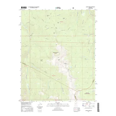
2017 Map of Jicarita Peak
USGS Topo · Published 2017About this map
The high ridges of the Santa Fe Mountains and Sangre de Cristo Mountains converge here at the triple junction of Rio Arriba, Taos, and Mora counties. Central to this high-altitude landscape is Jicarita Peak, a prominent summit surrounded by technical terrain and glacial basins. To the south, Little Jicarita Peak stands above the headwaters of the Middle Fork Rio Santa Barbara and the E Fork Rio Santa Barbara, marking a primary drainage system for the region. The map reveals a network of alpine lakes, including Serpent Lake and the high-elevation Horseshoe Lake, which are linked by historic routes like the Angostura Cutoff and Indian Lake Trail. This 2017 survey details the complex boundary lines within the Carson National Forest and Santa Fe National Forest, illustrating how these protected lands encompass the watersheds of Indian Creek and Alamitos Cr.
Find a feature on this map
46 named features on this map. Tap any name to fly to it.
Don’t see what you’re looking for? This feature index may not catch every label — zoom into the map to look around manually.
Map Details
Editions of this 2017 Jicarita Peak Map
This is the sole edition of this map. No revisions or reprints were ever made.
Other maps of this area

1889 · Las Vegas
USGS Topo · 1:125,000

1889 · Santa Fe
USGS Topo · 1:125,000

1891 · Las Vegas
USGS Topo · 1:125,000

1893 · Las Vegas
USGS Topo · 1:125,000

1894 · Santa Fe
USGS Topo · 1:125,000

1954 · Santa Fe
USGS Topo · 1:250,000

1954 · Raton
USGS Topo · 1:250,000

1958 · Raton
USGS Topo · 1:250,000

1958 · Santa Fe
USGS Topo · 1:250,000
1963 · Truchas Peak
USGS Topo · 1:24,000