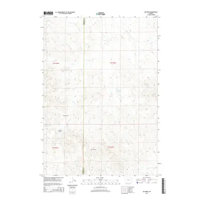
2015 Map of Jim Creek
USGS Topo · Published 2015About this map
Campbell Co and Weston Co meet along a prominent north-south boundary in this high-plains landscape, where the terrain is defined by a dense network of intermittent drainage channels. The central watershed is dominated by Jim Cr, which is fed by numerous tributaries including Trail Cr, Bell Cr, and Jake Cr. Human intervention in this arid environment is most visible at Harrel Reservoir, a small catchment along the upper reaches of Trail Cr. The topographical detail reveals a complex system of named draws and erosional features such as Williams Draw, Murphy Draw, and the starkly named Hells Canyon in the south. To the southeast, the flow eventually directs toward Lodgepole Cr, while the western portion of the map is characterized by prongs like Newel Prong and Baker Prong, illustrating the intricate dissection of the Wyoming prairie.
Find a feature on this map
22 named features on this map. Tap any name to fly to it.
Don’t see what you’re looking for? This feature index may not catch every label — zoom into the map to look around manually.
Map Details
Editions of this 2015 Jim Creek Map
This is the sole edition of this map. No revisions or reprints were ever made.
Other maps of this area

1918 · Moorcroft
USGS Topo · 1:125,000

1954 · Gillette
USGS Topo · 1:250,000

1955 · Newcastle
USGS Topo · 1:250,000

1955 · Gillette
USGS Topo · 1:250,000

1958 · Gillette
USGS Topo · 1:250,000

1958 · Newcastle
USGS Topo · 1:250,000

1962 · Gillette
USGS Topo · 1:250,000

1971 · Open A Ranch
USGS Topo · 1:24,000

1971 · Whitetail Creek
USGS Topo · 1:24,000

1971 · Rough Creek
USGS Topo · 1:24,000