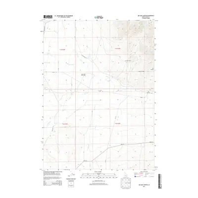
2013 Map of Jim Sage Canyon
USGS Topo · Published 2013About this map
Jim Sage Canyon and its associated Womack Canyon dominate the northeastern portion of this High Desert landscape, where seasonal drainages flow from the uplands toward the Upper Raft River Valley. The perennial Raft River meanders through the central basin, joined by numerous mountain-fed streams including Almo Cr, Grape Cr, and George Cr. This drainage network was vital for the early ranching operations of Cassia County, indicated by the presence of critical water sources like Reed Spring and Jim Sage Spring. Local transit is defined by a grid of rural routes including Narrows Rd and Strevell Rd, which connect the isolated canyons to the broader valley. The land is marked by distinct topographical features such as The Narrows, where the terrain constricts along the eastern boundary, illustrating the geographical constraints on early transport and settlement patterns in this part of Idaho.
Find a feature on this map
29 named features on this map. Tap any name to fly to it.
Don’t see what you’re looking for? This feature index may not catch every label — zoom into the map to look around manually.
Map Details
Editions of this 2013 Jim Sage Canyon Map
This is the sole edition of this map. No revisions or reprints were ever made.
Other maps of this area

1954 · Pocatello
USGS Topo · 1:250,000

1954 · Brigham City
USGS Topo · 1:250,000

1958 · Pocatello
USGS Topo · 1:250,000

1958 · Brigham City
USGS Topo · 1:250,000

1959 · Park Valley
USGS Topo · 1:62,500

1959 · Yost
USGS Topo · 1:62,500

1962 · Brigham City
USGS Topo · 1:250,000

1968 · Almo
USGS Topo · 1:24,000

1968 · Cache Peak
USGS Topo · 1:24,000

1968 · Jim Sage Canyon
USGS Topo · 1:24,000