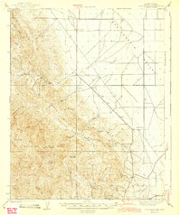
1943 Map of Joaquin Rocks
USGS Topo · Published 1943About this map
Joaquin Rocks dominate the high terrain of western Fresno County, marking a rugged transition between the Cervo Hills and the floor of the San Joaquin Valley. This 1943 survey documents a landscape of large-scale ranching and early petroleum infrastructure during the early war years. Notable homesteads such as Lillis Ranch and Domengine Ranch are positioned near vital water sources like Domengine Spr, while the Mack Pumping Sta indicates the regional industrial activity in the foothills. The northern valley floor is largely open, punctuated only by the Cantua Sch and the intermittent flow of Cantua Creek. To the south, steep canyons like Nunez Can and Diaz Canyon carve through the Ridge, leading toward peaks like Black Mtn. The map preserves a moment when remote outposts like The Clearing and Jordan Ranch still served as primary landmarks in this high-desert environment.
Find a feature on this map
27 named features on this map. Tap any name to fly to it.
Don’t see what you’re looking for? This feature index may not catch every label — zoom into the map to look around manually.
Map Details
Editions of this 1943 Joaquin Rocks Map
2 editions found

Other maps of this area

1912 · Coalinga
USGS Topo · 1:125,000

1913 · Panoche
USGS Topo · 1:125,000

1915 · Priest Valley
USGS Topo · 1:125,000

1923 · Levis
USGS Topo · 1:31,680

1923 · Englebrecht Ranch
USGS Topo · 1:31,680

1923 · Monocline Ridge
USGS Topo · 1:31,680

1925 · San Joaquin
USGS Topo · 1:31,680

1928 · Delta Farms No 3
USGS Topo · 1:31,680

1931 · Towne Oil Station
USGS Topo · 1:31,680

1931 · Mouth of Cantua Creek
USGS Topo · 1:31,680