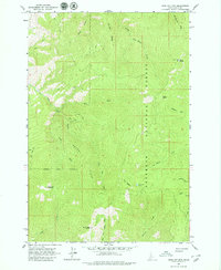
1963 Map of John Day Mtn
USGS Topo · Published 1979About this map
Nezperce National Forest dominates this Idaho landscape, where the steep canyons and ridges define a territory shaped by water and high-altitude observation. The peak of John Day Mountain and the high point at Southwest Butte anchor the southern portion of the sheet, while a Lookout Tower sits perched at Slate Point to the northeast, overseeing the dense drainage basins. The map illustrates a complex network of seasonal access, dominated by a series of labels for Jeep Trails and primitive trails that navigate the slopes of Brushy Ridge and Allison Ridge. This network reveals how the Forest Service and early recreationists accessed remote pockets like Nut Basin Lake and the various forks of John Day Creek and Allison Creek before more modern infrastructure reached this high-country terrain.
Find a feature on this map
26 named features on this map. Tap any name to fly to it.
Don’t see what you’re looking for? This feature index may not catch every label — zoom into the map to look around manually.
Map Details
Editions of this 1963 John Day Mtn Map
2 editions found
Other maps of this area

1938 · Riggins
USGS Topo · 1:96,000

1945 · Riggins
USGS Topo · 1:125,000

1955 · Grangeville
USGS Topo · 1:250,000

1959 · Grangeville
USGS Topo · 1:250,000

1963 · John Day Mtn
USGS Topo · 1:24,000

1963 · Lucile
USGS Topo · 1:24,000

1963 · McKinzie Creek
USGS Topo · 1:24,000

1963 · Slate Creek
USGS Topo · 1:24,000
1963 · Dairy Mountain
USGS Topo · 1:24,000
1963 · Florence
USGS Topo · 1:24,000