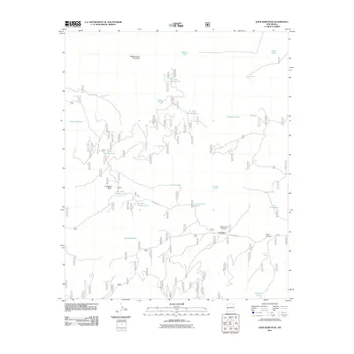
2011 Map of John Kerr Peak
USGS Topo · Published 2011About this map
John Kerr Peak and the high elevations of Wagontongue Mountain dominate this corner of Catron County, where a complex network of forest roads and water infrastructure supports high-altitude ranching and land management. The 2011 landscape is defined by its water sources, ranging from natural outflows like Govina Canyon Spring and Willow Spring to man-made catchments such as Todd Cienega Tank and Spurgeon Tank. These features suggest a working landscape where water security is paramount for livestock and wildlife. Movement through the area is dictated by the terrain of Cottonwood Canyon and Wine Canyon, with Long Canyon Windmill and Sawmill Tank serving as essential landmarks for navigation. The map provides a detailed view of the infrastructure within the national forest, including Forest Rd 289 and Forest Rd 47, which connect the isolated springs and tanks across this high-desert mountain environment.
Find a feature on this map
31 named features on this map. Tap any name to fly to it.
Don’t see what you’re looking for? This feature index may not catch every label — zoom into the map to look around manually.
Map Details
Editions of this 2011 John Kerr Peak Map
This is the sole edition of this map. No revisions or reprints were ever made.
Other maps of this area

1915 · Reserve
USGS Topo · 1:125,000

1918 · Pelona
USGS Topo · 1:125,000

1918 · Reserve
USGS Topo · 1:125,000

1954 · Clifton
USGS Topo · 1:250,000

1957 · Clifton
USGS Topo · 1:250,000

1958 · Clifton
USGS Topo · 1:250,000

1962 · Clifton
USGS Topo · 1:250,000
1965 · Aragon
USGS Topo · 1:24,000
1965 · Eagle Peak
USGS Topo · 1:24,000
1965 · Squirrel Springs Canyon
USGS Topo · 1:24,000