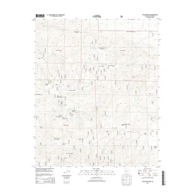
2013 Map of John Kerr Peak
USGS Topo · Published 2013About this map
John Kerr Peak rises as a prominent landmark within this high-elevation landscape of the Gila National Forest in New Mexico. The Continental Divide winds through the western portion of the map, separating the drainages that flow toward the Atlantic and Pacific oceans. This area is characterized by an intricate network of canyons and peaks, including the Tularosa Mountains and Wagontongue Mtn. Life in this arid environment revolves around scattered water sources and livestock infrastructure, evidenced by numerous named springs and tanks such as Wine Spring, Damian Spring, and Todd Cienega Tank. Transportation is limited to rugged routes like Forest Rd 289 and Forest Rd 41, which navigate the steep terrain of Govina Canyon and Squirrel Springs Canyon. The map reveals a landscape managed for natural resources and grazing, where every canyon and water hole carries a specific name essential for navigation and land management.
Find a feature on this map
47 named features on this map. Tap any name to fly to it.
Don’t see what you’re looking for? This feature index may not catch every label — zoom into the map to look around manually.
Map Details
Editions of this 2013 John Kerr Peak Map
This is the sole edition of this map. No revisions or reprints were ever made.
Other maps of this area

1915 · Reserve
USGS Topo · 1:125,000

1918 · Pelona
USGS Topo · 1:125,000

1918 · Reserve
USGS Topo · 1:125,000

1954 · Clifton
USGS Topo · 1:250,000

1957 · Clifton
USGS Topo · 1:250,000

1958 · Clifton
USGS Topo · 1:250,000

1962 · Clifton
USGS Topo · 1:250,000
1965 · Aragon
USGS Topo · 1:24,000
1965 · Eagle Peak
USGS Topo · 1:24,000
1965 · Squirrel Springs Canyon
USGS Topo · 1:24,000