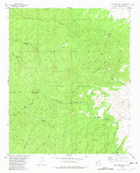
1981 Map of John Kerr Peak
USGS Topo · Published 1981About this map
Continental Divide crests through this high-elevation landscape within the Gila National Forest, defining the watershed between the peaks of the Gila Mountains and the lower canyons. The 1981 mapping shows a terrain dominated by remote water sources and cattle infrastructure, where numerous named tanks and springs like Govina Canyon Spring and Cottonwood Tank supported ranching and forestry. The central landmark, John Kerr Peak, towers over a network of rugged paths including the Back Trail and several Jeep Trails. This survey preserves the exact locations of many essential water points such as Long Canyon Windmill and North Squirrel Springs, which were critical for navigating this arid environment before modern developments. The presence of the Tularosa and Wagontongue Mountain indicates the prominence of these named ridges in local navigation and land management.
Find a feature on this map
36 named features on this map. Tap any name to fly to it.
Don’t see what you’re looking for? This feature index may not catch every label — zoom into the map to look around manually.
Map Details
Editions of this 1981 John Kerr Peak Map
This is the sole edition of this map. No revisions or reprints were ever made.
Other maps of this area

1915 · Reserve
USGS Topo · 1:125,000

1918 · Pelona
USGS Topo · 1:125,000

1918 · Reserve
USGS Topo · 1:125,000

1954 · Clifton
USGS Topo · 1:250,000

1957 · Clifton
USGS Topo · 1:250,000

1958 · Clifton
USGS Topo · 1:250,000

1962 · Clifton
USGS Topo · 1:250,000
1965 · Aragon
USGS Topo · 1:24,000
1965 · Eagle Peak
USGS Topo · 1:24,000
1965 · Squirrel Springs Canyon
USGS Topo · 1:24,000