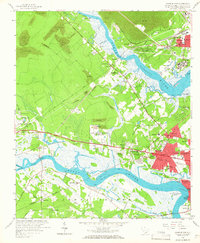
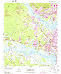
1958 Map of Johns Island
USGS Topo · Published 1966About this map
The Ashley River and Stono River define this coastal landscape, which in the late 1950s remained a mix of historic estates, agricultural research, and burgeoning suburban development. Significant cultural landmarks like Drayton Hall and Magnolia Gardens sit north of a landscape dotted with numerous Strip Mines. The mid-century industrial and transport network is highly visible, featuring the Atlantic Coast Line and Seaboard Air Line railroads, with local stops such as Stono Sta and Dupont Sta. Institutional presence is notable through the U S Department of Agriculture Experiment Farm and the Clemson College Experiment Farm. To the east, the growth of North Charleston is evidenced by neighborhoods like Wando Woods and Waylyn, while smaller communities like Maryville and Red Top maintain their distinct footprints near the Intracostal Waterway.
Find a feature on this map
83 named features on this map. Tap any name to fly to it.
Don’t see what you’re looking for? This feature index may not catch every label — zoom into the map to look around manually.
Map Details
Editions of this 1958 Johns Island Map
5 editions found
Other maps of this area

1919 · Ladson
USGS Topo · 1:21,120

1919 · Johns Island
USGS Topo · 1:21,120

1919 · Wadmelaw Island
USGS Topo · 1:62,500

1919 · Melgrove
USGS Topo · 1:21,120

1919 · Charleston
USGS Topo · 1:21,120

1919 · James Island
USGS Topo · 1:21,120

1919 · Legareville
USGS Topo · 1:21,120

1920 · Ravenels
USGS Topo · 1:62,500

1940 · Melgrove
USGS Topo · 1:24,000

1943 · Legareville
USGS Topo · 1:24,000