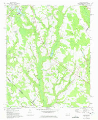
1971 Map of Johns
USGS Topo · Published 1975About this map
St Andrews College anchors the northern edge of this landscape where the coastal plain of North Carolina meets the South Carolina border. The Laurinburg and Southern railroad cuts a diagonal path through the terrain, serving rural communities like Johns and Hasty. The map reveals a dense network of country churches and schools that once defined the social fabric of Scotland and Robeson counties, including the South Scotland Sch, Smyrna Ch, and the Jerusalem Ch.
Find a feature on this map
49 named features on this map. Tap any name to fly to it.
Don’t see what you’re looking for? This feature index may not catch every label — zoom into the map to look around manually.
Map Details
Editions of this 1971 Johns Map
2 editions found

Other maps of this area

1942 · Rockingham
USGS Topo · 1:125,000

1949 · Gibson
USGS Topo · 1:24,000

1949 · Laurinburg
USGS Topo · 1:24,000

1949 · Wakulla
USGS Topo · 1:24,000

1949 · Hamlet
USGS Topo · 1:62,500

1949 · Laurinburg
USGS Topo · 1:62,500

1953 · Florence
USGS Topo · 1:250,000

1954 · Florence
USGS Topo · 1:250,000

1957 · Laurinburg
USGS Topo · 1:24,000

1971 · Minturn
USGS Topo · 1:24,000