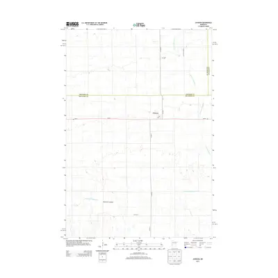
2013 Map of Johnson
USGS Topo · Published 2013About this map
The settlement of Johnson serves as the focal point of this Big Stone County landscape, situated where MN-28 intersects with 4th Ave. This map reveals a region defined by agricultural engineering and seasonal hydrology, as seen in the extensive network of drainage features like County Ditch Number Eight and County-Ditch-Number-Eleven. These man-made channels navigate a prairie terrain marked by the ephemeral Moonshine Lakebed and the meandering headwaters of W Fork Twelvemile Cr. Local history is anchored by the Trinity Cem located to the north, providing a quiet record of early residents in the tri-county corner where Big Stone, Traverse, and Stevens counties meet. The presence of a Po in Johnson highlights its status as a critical rural mail and service hub for the surrounding farming community in the early 21st century.
Find a feature on this map
15 named features on this map. Tap any name to fly to it.
Don’t see what you’re looking for? This feature index may not catch every label — zoom into the map to look around manually.
Map Details
Editions of this 2013 Johnson Map
This is the sole edition of this map. No revisions or reprints were ever made.
Other maps of this area

1910 · Chokio
USGS Topo · 1:62,500

1912 · Chokio
USGS Topo · 1:62,500

1950 · Graceville
USGS Topo · 1:62,500

1953 · Ortonville
USGS Topo · 1:62,500

1953 · Milbank
USGS Topo · 1:250,000

1958 · Milbank
USGS Topo · 1:250,000

1968 · Artichoke Lake NW
USGS Topo · 1:24,000

1971 · Dismal Swamp
USGS Topo · 1:24,000
1971 · Clinton
USGS Topo · 1:24,000
1973 · Chokio NW
USGS Topo · 1:24,000