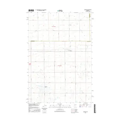
2016 Map of Johnson
USGS Topo · Published 2016About this map
Johnson sits at a crossroads of the western Minnesota prairie, serving as a focal point for this rural landscape where Big Stone, Traverse, and Stevens counties meet. The terrain is defined by its agricultural management and subtle hydrology, featuring extensive irrigation and drainage works like County Ditch Number Eight and County Ditch Number Eleven. These man-made channels intersect the natural flow of the W Fork Twelvemile Cr, illustrating the intensive land use required for high-yield farming in the region. Near the southern portion of the map, the Moonshine Lakebed indicates a dry basin that once held water, now integrated into the surrounding grid of fields. Religious and social life in this quiet township centers around the Trinity Cem, located just north of the village center, providing a genealogical anchor for local families who have worked this land for generations.
Find a feature on this map
35 named features on this map. Tap any name to fly to it.
Don’t see what you’re looking for? This feature index may not catch every label — zoom into the map to look around manually.
Map Details
Editions of this 2016 Johnson Map
This is the sole edition of this map. No revisions or reprints were ever made.
Other maps of this area

1910 · Chokio
USGS Topo · 1:62,500

1912 · Chokio
USGS Topo · 1:62,500

1950 · Graceville
USGS Topo · 1:62,500

1953 · Ortonville
USGS Topo · 1:62,500

1953 · Milbank
USGS Topo · 1:250,000

1958 · Milbank
USGS Topo · 1:250,000

1968 · Artichoke Lake NW
USGS Topo · 1:24,000

1971 · Dismal Swamp
USGS Topo · 1:24,000
1971 · Clinton
USGS Topo · 1:24,000
1973 · Chokio NW
USGS Topo · 1:24,000