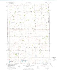
1974 Map of Johnson
USGS Topo · Published 1976About this map
Johnson sits at the heart of this mid-1970s western Minnesota landscape, serving as a primary rail point along the Burlington Northern line. The terrain is defined by a sophisticated water management system, characterized by long drainage routes such as County Ditch No 11 and County Ditch No 8 that bisect the agricultural townships of Leonardsville and Moonshine. Local landmarks include the Trinity Ch in the northern section and a Substation south of the main rail line.
Find a feature on this map
18 named features on this map. Tap any name to fly to it.
Don’t see what you’re looking for? This feature index may not catch every label — zoom into the map to look around manually.
Map Details
Editions of this 1974 Johnson Map
This is the sole edition of this map. No revisions or reprints were ever made.
Other maps of this area

1910 · Chokio
USGS Topo · 1:62,500

1912 · Chokio
USGS Topo · 1:62,500

1950 · Graceville
USGS Topo · 1:62,500

1953 · Ortonville
USGS Topo · 1:62,500

1953 · Milbank
USGS Topo · 1:250,000

1958 · Milbank
USGS Topo · 1:250,000

1968 · Artichoke Lake NW
USGS Topo · 1:24,000

1971 · Dismal Swamp
USGS Topo · 1:24,000
1971 · Clinton
USGS Topo · 1:24,000
1973 · Chokio NW
USGS Topo · 1:24,000