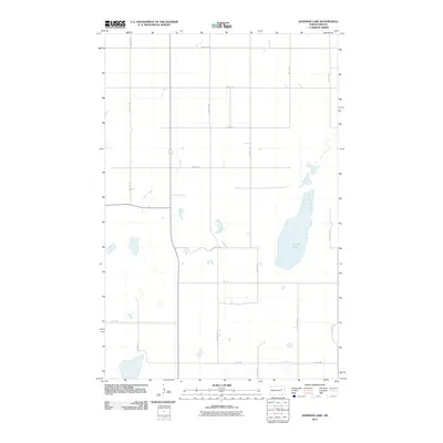
2011 Map of Johnson Lake
USGS Topo · Published 2011About this map
Johnson Lake sits at the heart of this Nelson County landscape, an elongated body of water that anchors a region defined by its precise section-line road network. The drainage of Colvin Creek meanders through the western half of the quadrangle, contrasting with the rigid geometry of the surrounding agricultural land. In the early 21st century, this area remains a quintessential example of the Great Plains' rural infrastructure, where thoroughfares such as 23rd St NE and 92nd Ave NE divide the terrain into predictable square-mile blocks. The 2011 survey by the U.S. Geological Survey documents a sparse but functional landscape, where small, scattered wetlands and intermittent water bodies punctuate the prairie between established routes like 97th Ave NE and 15th St NE.
Find a feature on this map
18 named features on this map. Tap any name to fly to it.
Don’t see what you’re looking for? This feature index may not catch every label — zoom into the map to look around manually.
Map Details
Editions of this 2011 Johnson Lake Map
This is the sole edition of this map. No revisions or reprints were ever made.
Other maps of this area

1930 · Pekin
USGS Topo · 1:62,500

1930 · Hamar
USGS Topo · 1:62,500

1951 · Tolna
USGS Topo · 1:24,000

1951 · Pekin
USGS Topo · 1:62,500

1952 · New Rockford
USGS Topo · 1:250,000

1956 · New Rockford
USGS Topo · 1:250,000
1961 · Lake Coe
USGS Topo · 1:24,000

1961 · McHenry
USGS Topo · 1:24,000
1961 · Juanita
USGS Topo · 1:24,000

1961 · Johnson Lake
USGS Topo · 1:24,000