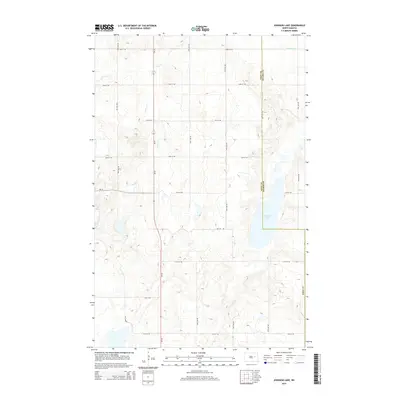
2014 Map of Johnson Lake
USGS Topo · Published 2014About this map
Johnson Lake lies at the heart of this Nelson County landscape, where the prairie of North Dakota transitions into a complex system of seasonal water bodies and sloughs. This 2014 survey captures the geometric precision of the Great Plains' section-line road system, defined by thoroughfares like 95th Ave NE and 23rd St NE. The map illustrates a predominantly agricultural and hydrologic character, with the winding course of Colvin Cr and the northern expanse of Kelly Slough breaking the rigid grid. Situated along the boundary where Eddy and Nelson Counties meet, the area is bisected by the critical regional corridors of ND-15 and ND-20. These state highways connect the remote farmsteads and lakefronts to the larger trade centers beyond the quadrangle's edges, reflecting a modern era of rural connectivity.
Find a feature on this map
23 named features on this map. Tap any name to fly to it.
Don’t see what you’re looking for? This feature index may not catch every label — zoom into the map to look around manually.
Map Details
Editions of this 2014 Johnson Lake Map
This is the sole edition of this map. No revisions or reprints were ever made.
Other maps of this area

1930 · Pekin
USGS Topo · 1:62,500

1930 · Hamar
USGS Topo · 1:62,500

1951 · Tolna
USGS Topo · 1:24,000

1951 · Pekin
USGS Topo · 1:62,500

1952 · New Rockford
USGS Topo · 1:250,000

1956 · New Rockford
USGS Topo · 1:250,000
1961 · Lake Coe
USGS Topo · 1:24,000

1961 · McHenry
USGS Topo · 1:24,000
1961 · Juanita
USGS Topo · 1:24,000

1961 · Johnson Lake
USGS Topo · 1:24,000