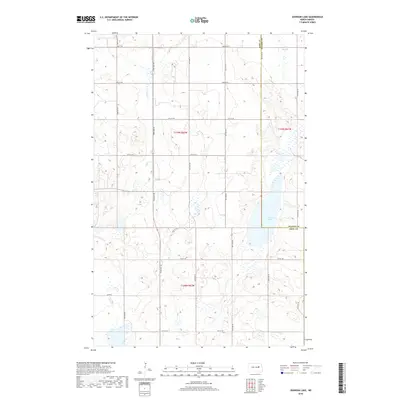
2018 Map of Johnson Lake
USGS Topo · Published 2018About this map
Johnson Lake sits at the heart of this landscape, straddling the boundary where Nelson and Eddy counties meet. The terrain is defined by a dense network of prairie potholes and wetlands, typical of the drift prairie region. Water drainage is channeled through Colvin Cr and Kelly Slough, which cut across the north and eastern sections of the quadrangle.
Find a feature on this map
22 named features on this map. Tap any name to fly to it.
Don’t see what you’re looking for? This feature index may not catch every label — zoom into the map to look around manually.
Map Details
Editions of this 2018 Johnson Lake Map
This is the sole edition of this map. No revisions or reprints were ever made.
Other maps of this area

1930 · Pekin
USGS Topo · 1:62,500

1930 · Hamar
USGS Topo · 1:62,500

1951 · Tolna
USGS Topo · 1:24,000

1951 · Pekin
USGS Topo · 1:62,500

1952 · New Rockford
USGS Topo · 1:250,000

1956 · New Rockford
USGS Topo · 1:250,000
1961 · Lake Coe
USGS Topo · 1:24,000

1961 · McHenry
USGS Topo · 1:24,000
1961 · Juanita
USGS Topo · 1:24,000

1961 · Johnson Lake
USGS Topo · 1:24,000