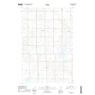
2020 Map of Johnson Lake
USGS Topo · Published 2020About this map
Johnson Lake dominates the eastern portion of this prairie landscape, where the boundary between Eddy and Nelson counties bisects the terrain. This rural expanse in North Dakota is defined by a rhythmic grid of gravel roads, including 93rd Ave NE and 17th St NE, which connect isolated homesteads across the townships of t149n r62w and t149n r61w. In the northeast corner near Kelly Slough, the Gethsemane Cem stands as a quiet landmark for local genealogical research. The hydrology of the area is characterized by seasonal drainage and wetlands, with Colvin Cr winding through the western sections. The map preserves the precise layout of the Public Land Survey System, showing the small depressions and sloughs typical of the drift prairie before modern land alterations.
Find a feature on this map
24 named features on this map. Tap any name to fly to it.
Don’t see what you’re looking for? This feature index may not catch every label — zoom into the map to look around manually.
Map Details
Editions of this 2020 Johnson Lake Map
This is the sole edition of this map. No revisions or reprints were ever made.
Other maps of this area

1930 · Pekin
USGS Topo · 1:62,500

1930 · Hamar
USGS Topo · 1:62,500

1951 · Tolna
USGS Topo · 1:24,000

1951 · Pekin
USGS Topo · 1:62,500

1952 · New Rockford
USGS Topo · 1:250,000

1956 · New Rockford
USGS Topo · 1:250,000
1961 · Lake Coe
USGS Topo · 1:24,000

1961 · McHenry
USGS Topo · 1:24,000
1961 · Juanita
USGS Topo · 1:24,000

1961 · Johnson Lake
USGS Topo · 1:24,000