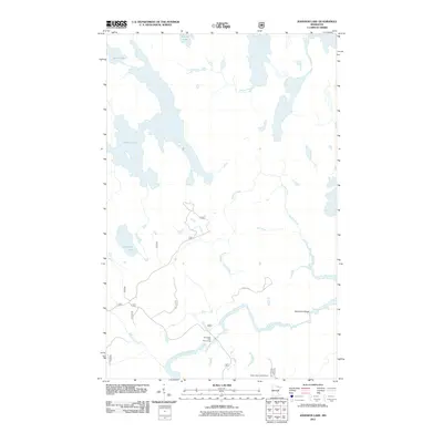
2011 Map of Johnson Lake
USGS Topo · Published 2011About this map
The Vermilion River and its dramatic Vermilion Gorge anchor this survey of the Superior National Forest region in northern Saint Louis County. The landscape is defined by a complex network of waterways, where the Rainy River flows near the northern boundary and Rollick Creek meanders toward the center. This map captures the area's transition into a managed recreational wilderness, featuring the Vermillion Falls Picnic Area and the Crane Lake Lookout Tower, a site of historic forest fire surveillance. The terrain is marked by numerous glacial water bodies, including Johnson Lake, Franklin Lake, and Spring Lake. A web of forest service routes like Forest Rd and 491e provides the primary access through the dense woodland, illustrating the infrastructure required for modern forestry and conservation efforts in this borderland territory.
Find a feature on this map
21 named features on this map. Tap any name to fly to it.
Don’t see what you’re looking for? This feature index may not catch every label — zoom into the map to look around manually.
Map Details
Editions of this 2011 Johnson Lake Map
This is the sole edition of this map. No revisions or reprints were ever made.
Other maps of this area

1954 · International Falls
USGS Topo · 1:250,000

1957 · International Falls
USGS Topo · 1:250,000

1958 · International Falls
USGS Topo · 1:250,000

1963 · Echo Lake
USGS Topo · 1:24,000

1963 · Redhorse Bay
USGS Topo · 1:24,000

1963 · Crane Lake
USGS Topo · 1:24,000

1967 · Namakan Island
USGS Topo · 1:24,000

1967 · Kabustasa Lake
USGS Topo · 1:24,000

1967 · Marion Lake
USGS Topo · 1:24,000

1967 · Hale Bay
USGS Topo · 1:24,000