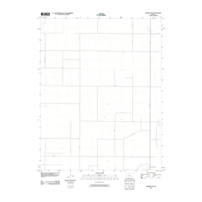
2010 Map of Johnson NE
USGS Topo · Published 2010About this map
Little Bear Creek and Bear Creek cut through the high plains of Stanton County in this 2010 survey. The landscape is defined by the rigid geometry of the Public Land Survey System, with a network of rural roads such as W Rd 8 and Road N following section lines across the agricultural terrain. Infrastructure is sparse, primarily supporting water management and transit, including a Gaging Station on the southern reach of Bear Creek and several isolated wells scattered across the northern sections. State Hwy 27 provides the primary north-south corridor, connecting this rural expanse to the larger regional trade centers. The map reveals the meticulous organization of Western Kansas farmland, where nearly every mile is accounted for by a named road or property boundary.
Find a feature on this map
17 named features on this map. Tap any name to fly to it.
Don’t see what you’re looking for? This feature index may not catch every label — zoom into the map to look around manually.
Map Details
Editions of this 2010 Johnson NE Map
This is the sole edition of this map. No revisions or reprints were ever made.
Other maps of this area

1900 · Syracuse
USGS Topo · 1:125,000

1920 · Syracuse
USGS Topo · 1:125,000

1955 · Dodge City
USGS Topo · 1:250,000

1958 · Dodge City
USGS Topo · 1:250,000

1959 · Dodge City
USGS Topo · 1:250,000

1959 · Big Bow NW
USGS Topo · 1:24,000

1959 · Big Bow SW
USGS Topo · 1:24,000

1966 · Syracuse West SW
USGS Topo · 1:24,000

1966 · Syracuse East SW
USGS Topo · 1:24,000
1966 · Syracuse West SE
USGS Topo · 1:24,000